
IOWA, USA — Download the We Are Iowa app for the latest forecast, interactive radar and livestream video of severe weather coverage.
For a complete list of weather-related closings, click here.
Record-high temperatures quickly moved to dangerously-high winds Wednesday evening throughout Iowa.
School districts are dismissed early, and the mile-long bridge on Iowa 415 over Saylorville Lake closed at noon Wednesday because of the high winds. It has since reopened Thursday morning.
Local 5 will provide up-to-date information and resources below. You can always text WEATHER to 515-457-1026 for the latest weather forecast.
10:15 p.m.
The National Weather Service says Wednesday has set a record for the most number of hurricane-force thunderstorm wind gusts in a day, dating back to 2004. That means they recorded more than 55 wind gusts that blew 75+ miles per hour.

10:00 p.m.
Local 5 Chief Meteorologist Brad Edwards estimates 11 tornadoes may have touched down Wednesday night. This data will be updated on Thursday after officials complete their surveys.
A Facebook post from the Rudd Rockford Marble Rock Community School District says classes are canceled for Wednesday. The RRMR school building will be open for folks to take showers, get a warm meal and stay warm.
At this time, 148,225 outages are reported throughout the state.
9:30 p.m.
Local 5 crews are out assessing damage in central Iowa. There are 145,689 outages across the state.
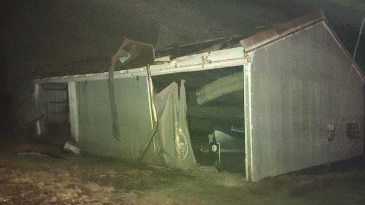
Local 5 is also investigating reports of severe damage in the town of Rudd, which is located in Floyd County. The sheriff's office is advising people to stay away from the area.
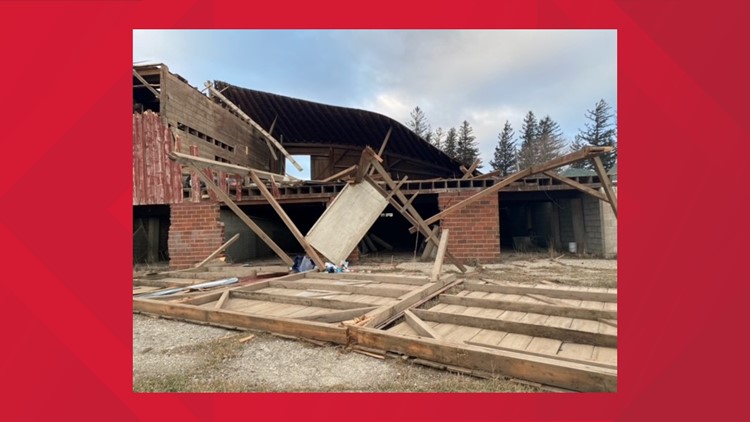
Reports of damage have come in about the town's library, city hall and possibly a church being leveled. No injuries have been reported.
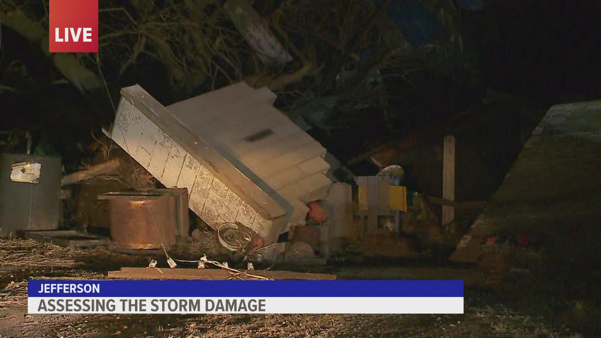
Another one of the hardest-hit areas is the town of Jefferson. Power lines are down and significant damage was witnessed by Local 5's Laryssa Leone and Theo Bowie.
8 p.m.
There are no more active severe weather warnings in central Iowa.
Power outages increase
There are 105,887 power outages across the state according to PowerOutage.US. Some of the hardest-hit areas in central Iowa are Greene County and Guthrie counties where close to 70% of customers are without power and Wright County, where 88% of customers are without power.
Strong winds continue
The National Weather Service reported an 82 MPH wind gust at Ottumwa Airport just before 8 p.m. NWS said that was due to thunderstorms but "non-thunderstorm wind gusts are ramping up across western Iowa."
7:30 p.m.
Hardin, Jasper, Marion, Marshall, and Poweshiek counties remain under Severe Thunderstorm Warnings.
Damage reports roll in
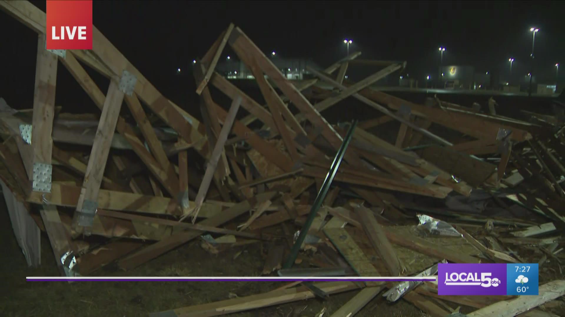
Johnston Police Department said the roof of an outdoor learning environment built by students was blown into the street. A public works team has since cleared it from the roadway.
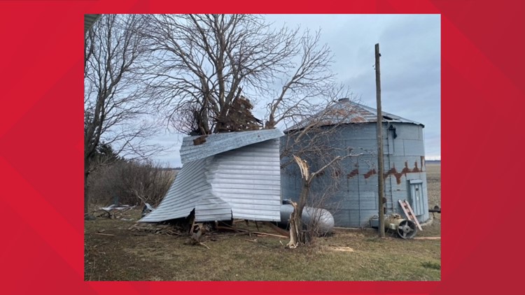
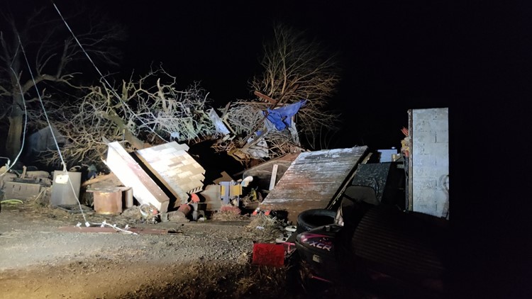
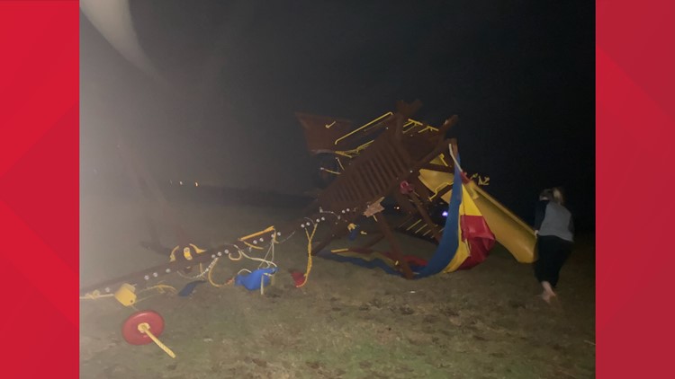
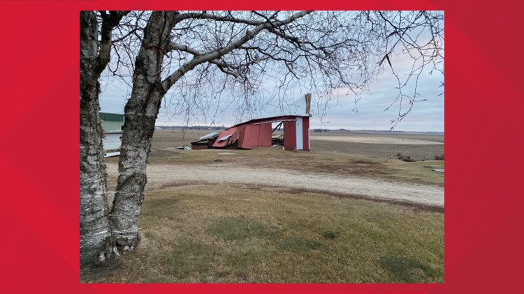
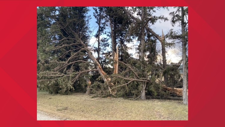
Gallery: Severe weather across Iowa Wednesday


Power lines reported down in Guthrie.
Local 5 also received reports of "flattened homes in Bayard and campers flipped in Bagley."
7:15 p.m.
I-35 southbound blocked
Both lanes of southbound I-35 are blocked after a "multi-semi crash" at mile marker 65 near Cumming, according to the Iowa State Patrol.
Power outages increase
66,699 power outages are reported across the state according to PowerOutage.US. Most outages are on the western side of the state, but reaching into central Iowa. 60% of customers in Wright County, 67% in Greene County and 52% in Hamilton County are without power.
7 p.m.
Ottumwa, Oskaloosa and Pella are under a Severe Thunderstorm Warning until 8:15 p.m.
Polk, Jasper, Marion and Marshall counties are under a Severe Thunderstorm Warning until 7:30 p.m.
"The main line of storms has moved out of Polk and Warren Counties but there is a secondary line of weaker storms moving into Waukee area," NWS Des Moines tweeted. "That should move east of Waukee shortly past 7 p.m.
Strong winds continue
NWS Des Moines reported 61 MPH winds at the Des Moines airport, 60 MPH in Ankeny and 83 MPH in Mason City.
6:30 p.m.
DSM flights canceled
Eight flights arriving into DSM and one flight departing from DSM have been canceled.
Severe Thunderstorm Warning extended for Des Moines area
If you are in the red area, take shelter immediately.
6:20 p.m.
Tornado Warning issued for Buffalo Center and surrounding areas
If you are in the red area take shelter immediately.
Power outages reach central Iowa
41,117 power outages are reported across the state according to PowerOutage.US. Most outages are on the western side of the state, but reaching into the western part of central Iowa. 65.5% of customers in Greene County are without power.
6 p.m.
80+ MPH wind gusts moving into Des Moines suburbs
If you are in the area take shelter immediately.
Tornado Warning issued for Pocahontas County
If you are in the area take shelter immediately. This warning expires at 6:30 p.m.
Tornado Warning issued for Boone County
If you are in the area take shelter immediately. This warning expires at 6:15 p.m.
Tornado Warning issued for Gilmore City, Livermore, Bode areas
If you are in the red area take shelter immediately.
5:50 p.m.
Thousands without power in western Iowa
26,972 power outages are reported across the state according to PowerOutage.US. Most outages are on the western side of the state. Mills County looks to be hit the hardest with 67.2% of customers without electricity.
Severe Thunderstorm Warning issued for Ames, Marshalltown, Webster City areas
If you are in the red area take shelter immediately.
5:45 p.m.
Severe Thunderstorm Warning remains in place for Polk County as storms move into the Des Moines metro area.
5:30 p.m.
Tornado observed in Guthrie County
Tornado Warning issued for Fort Dodge, Jefferson, Gowrie area
If you are in the red areas take shelter immediately.
Tornado Warning issued for Pocahontas, Pomeroy, Fonda area
If you are in the red areas take shelter immediately.
Tornado warning issued for Boone County
5:15 p.m.
Tornado Warning issued for Dallas County
If you are in the red areas including Perry, Guthrie Center and Panora, take shelter immediately. The warning expires at 6 p.m.
Severe Thunderstorm Warning issued for Fort Dodge, Boone, Carroll Coon Rapids areas
If you are in the red areas take shelter immediately. The warning expires at 6:30 p.m.
Severe Thunderstorm Warning issued for Des Moines metro area
If you are in the red areas including Des Moines, West Des Moines and Ankeny, take shelter immediately. The warning expires at 6:30 p.m.
This is the first time sirens have been triggered in Iowa due to severe thunderstorms with high wind. Sirens are activated in advance of severe storms with wind speeds over 80 MPH as a result of the derecho.
Water main break reported in Waukee
A water main break has occurred and affects residents near Ashworth Road, Glacier Trail and Christy Lane according to the City of Waukee. Contractors are working to restore service.
Tornado reported on west side of Atlantic
If you are in this area, take shelter immediately.
4:50 p.m.
Power restored to Des Moines area, significant outages in western Iowa
PowerOutage.US is reporting more than 13,000 power outages across Iowa, mainly in the Council Bluffs Area. MidAmerican is reporting only a few dozen customers without power in the Des Moines area, down from more than 1,000 earlier Wednesday afternoon.
Tornado warning issued for additional parts of western Iowa
If you are in the red area including Atlantic, Audubon and Anita, take shelter immediately. This warning expires at 5:45 p.m.
Iowa 14 bridge at Red Rock Lake to close
Iowa 14 bridge at Red Rock Lake near Knoxville will close at 6 p.m. Wednesday due to high winds, according to the Iowa DOT. The DOT expects the bridge to reopen when winds subside.
Observed tornado moving into Cass County
Residents should take shelter immediately.
Tornado warning issued for additional parts of western Iowa
If you are in the red area, take shelter immediately. The warning expires at 5:30 p.m.
4:40 p.m.
Tornado warning issued for parts of southwestern Iowa
If you are in the Cass County area take shelter immediately. The warning expires at 5 p.m.
4:15 p.m.
Severe thunderstorm warning issued for additional parts of Iowa
If you are in the red areas, take shelter immediately. The warning expires at 5:30 p.m.
4 p.m.
Power outages reported across the state
PowerOutage.US is reporting more than 1,800 power outages across Iowa. MidAmerican is reporting nearly 900 in the Des Moines area.
The Johnston Police Department says stoplights are out at Northwest 86th Street and Chambery Boulevard. They tweeted this reminder to treat intersections as a four-way stop if lights are out.
Tornado warning issued for western Iowa
If you are in the red area, take shelter immediately. The warning expires at 4:15 p.m.
Severe thunderstorm warning issued for parts of Iowa
If you are in the red area, find shelter immediately. The warning expires at 5:15 p.m.
3:50 p.m.
A tornado warning has been issued for west Omaha, just across the border with Iowa.
Watch continuous weather coverage from the Local 5 Weather team
1:22 p.m.
Tornado watch issued for central and western Iowa
The watch includes most of Iowa and parts of Kansas, Minnesota, Missouri, Nebraska and South Dakota. It is set to expire at 8 p.m. Wednesday.
Resources
The safest place to be in the event of a tornado is on the lowest floor of a home or building (basements are most preferred), away from windows and doors. If you are in an apartment building without a basement, shelter in the smallest, most centrally located room on the bottom floor.
Check the latest watches and warnings
You can find all current watches and warnings here. Tornado warnings will be displayed in alphabetical order above severe thunderstorm warnings.
Report downed trees in Des Moines
MidAmerican customers: Report power outages
Customers can report outages here.
Timing of the storm
The threat level increased from a Level 2 to a Level 4 overnight, as confidence in severe storms is growing. A line of strong storms is set to race across the state between 4 and 9 p.m. Wednesday. They will begin on the western border near 4 p.m. before reaching the eastern side of the state later in the evening.
Storms will likely arrive in the Des Moines metro and near I-35 between 5 and 6 p.m.
Damaging wind gusts as high as 90 mph will be the primary threat, but a few tornadoes are also possible, primarily north of I-80. There have only been five December tornadoes in Iowa since 1950. Please have a way to receive watches and warnings when they are issued. The storms will be moving incredibly fast across the state, which means it may only storm in one particular area for 15-30 minutes altogether.
After 4 p.m., gusts could exceed 65 mph for some of us. A High Wind Warning is in effect from noon until pre-sunrise Thursday statewide. If you have not yet taken time to secure outdoor furniture, plants, Christmas decorations, and anything else you'd like to keep, now is that time.
The winds will not subside until a few hours after the bowing line of storms pass, most likely after midnight.
What is a High Wind Warning?
According to the National Weather Service, a High Wind Warning means "sustained winds of 40 mph for one hour and/or frequent gusts of at least 58 mph are occurring or expected within the next 36 hours."
For Polk and Dallas Counties, this is the first High Wind Warning since November 2015.
For much of the state, though, this is the first High Wind Warning in even longer.
- Tornado Watch: Be prepared! There are favorable conditions for tornadoes
- Tornado Warning: Take action! Tornado spotted or indicated by radar
- Tornado Emergency: Take action! Severe threat to life and property
Power outages
MidAmerican Energy is reporting more than 1,000 customers are without power in the Des Moines area as of 3:30 p.m. Their power outage map can be found here.
The Iowa Association of Electric Cooperatives (IAEC), which primarily serves rural areas, said it is monitoring conditions and crews are prepared to restore power if outages occur.
If your power goes out, IAEC says to call your local electric cooperative to report it, even if you think your neighbors may have called it in.
Customers can find a statewide map of current electric cooperative outages here.
“Safety is always our top priority,” said Scott Meinecke, IAEC director of safety. “Lineworkers are ready to respond to any outages, but they may not be able to climb poles or go up in the bucket if the conditions are too windy. Please be patient during these high wind situations and know that we are working as quickly and safely as possible to restore power.”
If you see downed power lines, do not touch them or drive over them—always assume they are energized and dangerous until an authority says otherwise. Call your local electric co-op or police to report downed lines, damaged poles or other damaged electrical equipment.
Flights
As of 4:15 p.m., six flights arriving into DSM and two flights departing from DSM have been canceled. Two departing flights have also been delayed.
► Download the We Are Iowa app
► Sign up for Local 5's "5 Things to Know" email newsletter
► Subscribe to Local 5 News on YouTube
WATCH: Morning Weather Update (Dec. 15, 2021)