DES MOINES, Iowa — Autumn is getting warmer, January and February are getting colder and snowier and it's getting wetter on average annually for Des Moines.
That's according to new climate data released Tuesday by the NCEI (National Centers for Environmental Information), a division of NOAA.
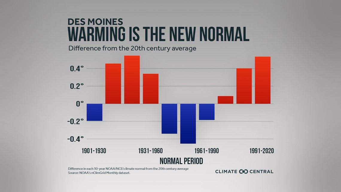
What meteorologists consider normal is based on a 30-year average.
Data from 1981-2010 was referenced previously to identify temperature, precipitation and snowfall averages for any particular location.
For the first time in a decade, averages are now based on data from 1991-2020, referencing numbers from more recent years.
This offers meteorologists and climatologists a better idea of how average temperature, precipitation and snowfall are changing over time.
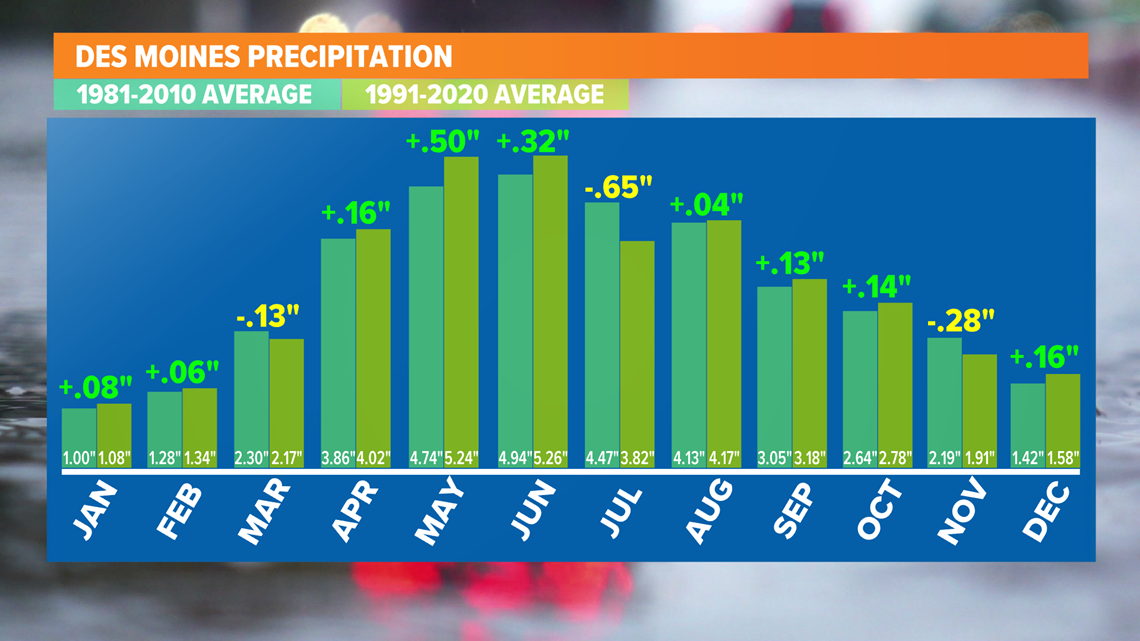
PRECIPITATION
For precipitation, the new data shows Des Moines is getting wetter by an average of 0.5" annually.
Nine out of 12 months reported an increase in average precipitation, with only March, August and November seeing a decline.
Most notably, May and June saw the biggest increase in average precipitation.

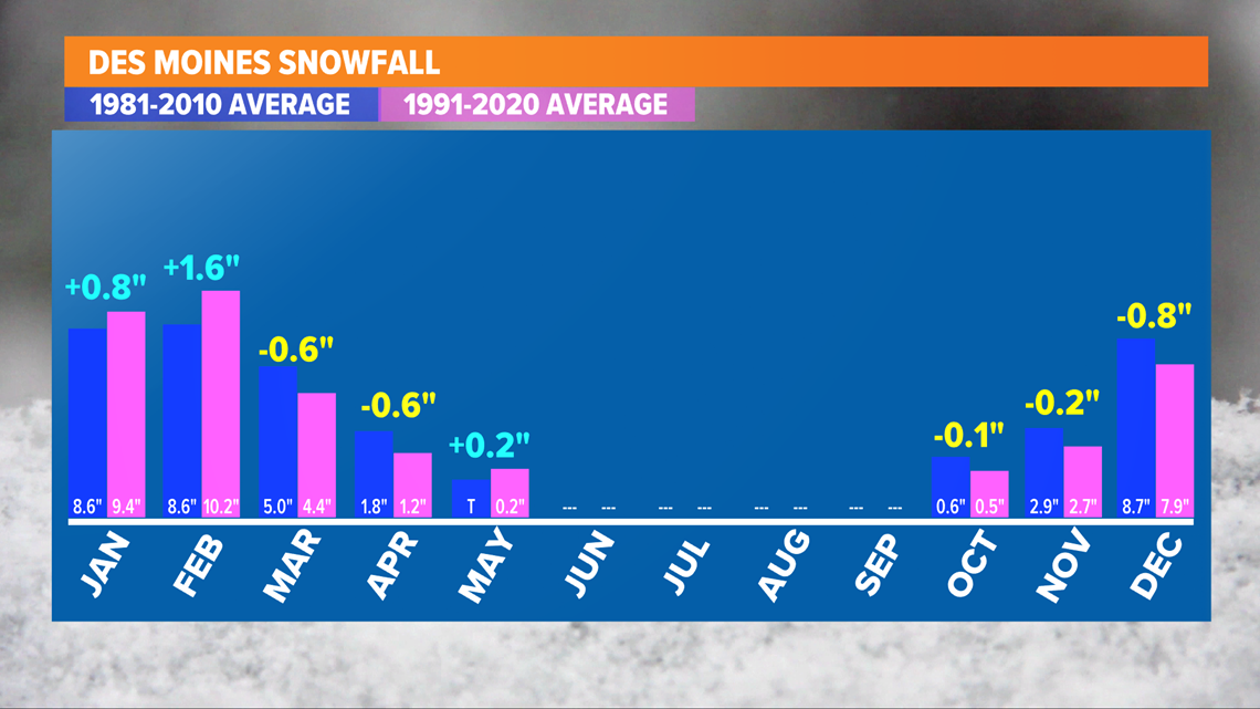
SNOWFALL
When it comes to snow, the data shows Des Moines has seen an average increase of about 0.3" of snow per year between 1991 and 2020.
The new average annual snowfall for Des Moines equates to 36.5", compared to the previous average of 36.2".
Looking at the data closer, Des Moines is seeing less snow in November and December, but more snow in January and February.
February might be the most surprising overall: an increase of 1.6" of snow for that month alone.

RELATED: Earth Day 2021: How climate change impacts Iowa, and how you can reduce your carbon footprint
TEMPERATURE
Finally, Des Moines has warmed, on average, roughly 0.4° annually.
Six out of 12 months have seen an increase in average high temperatures, while February, April, May, July and August experienced a slight decrease.
January reported no change in the average maximum temperature.

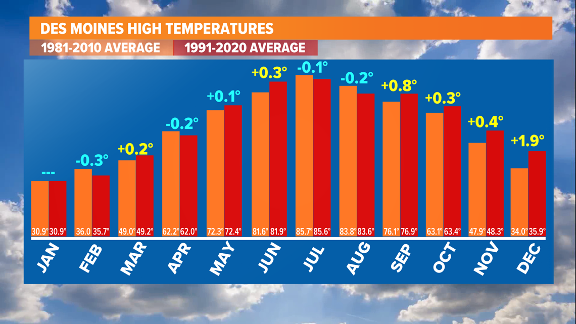
Similar trends were reported for the average minimum temperatures, or low temperatures, too.
Morning low temperatures fell in January and February, while they increased in October, November and December.
In summary: the data points to warmer falls, snowier and colder Januarys and February, and slightly wetter years for Des Moines.
Moving forward, these new climate normals will be used by Local 5's weather team as a reference for things like average highs, lows and precipitation.
It is also important to note averages do not necessarily point to trends for every season or every year.
Anomalies will likely occur in some seasons or years over the next 30 years before new climate normals are once again released.